Paleontological Fossil Sites on stamps and other philatelic items
UNDER CONSTRUCTION
The list of the Fossil Sites:
| Country |
Location Name |
|
| Aland (Finland) |
Jomala island |
|
| Argentina |
The Monumento natural Bosques Petrificados (the Natural monument Petrified Forest),
Ischigualasto formation - Talampaya Natural Parks.
|
|
| Australia |
Cliefden Caves,
Lord Howe Island,
Naracoorte Caves National Park,
Shark Bay,
Willandra Lakes.
|
|
| Bolivia |
Chuquisaca,
The Conservation League Torotoro (ACT).
|
|
| Brazil |
Lagoa Santa
|
|
| Canada |
Joggins Fossil Cliffs,
Miguasha National Park ,
Dinosaur Provincial Park ,
Mistaken Point.
|
|
| Colombia |
The Tatacoa Desert (Deserto de la Tatacoa).
|
|
| Czech Republic |
Iron Mountains,
Skryje village.
|
|
| Egypt |
Wadi Al-Hitan |
|
| France |
Domerat,
Géologique de Haute-Provence National Nature Reserve,
The National Natural Reserve of Hettange-Grande,
Menat,
Nolay,
Privas,
Toarcien National Nature Reserve,
Villers-sur-Mer.
|
|
| Germany |
Messel Pit,
The Dechen cave (German: Dechenhöhle)
|
|
| Italy |
Dunarobba fossil forest (Avigliano Umbro) |
|
| Vietnam |
Dong Van Karst Plateau Geopark,
Non Nuoc Cao Bang Geopark,
Dak Nong Geopark
|
Aland (
Finland) :
Jomala island, well known Ordovician fossil site of Aland.
 |
 |
|
Landscape of Jomala island on scenery stamp of Aland 2011,
MiNr.: 351, Scott: 323
|
Trilobites and Gastropods from the Ordovician period on stamps of Aland 1996,
MiNr.: 117-118, Scott: 85, 106
|
The best spot to collect fossils in Aland is Yttern's on the Jomala island.
The finds consist of
trilobites and gastropods from the Ordovician period.
Some of these fossils were depicted on
stamps of Aland in 1996 (see on the right).
These fossils can be seen in University Museum in Helsinki, Finland.
Some farmers allow to tourist to collect fossils on their fields at Ordovician limestone blocks.
[R1]
Known Philatelic items: commemorative
stamp of Aland 2011.
Argentina:
Ischigualasto formation - Talampaya Natural Parks. Paleontological location of Ischigualasto (Valle de la Luna)
These two contiguous parks extending over 275,300 ha in the desert region on the western border of
the Sierra Pampeanas of central Argentina, contain the most complete
continental fossil record known from the Triassic Period (245-208 million years ago).
Six geological formations in the parks contain fossils of a wide range of ancestors of mammals,
dinosaurs and plants revealing the evolution of vertebrates and the nature of
paleo-environments in the Triassic Period.
 |
 |
 |
| Argentina 1976, MiNr.: 1234, Scott: 1050. |
Argentina 1977, MiNr.: 1288, Scott: 1108. |
Argentina 2003, MiNr.: 2841, Scott: 2248e. |
It is the only place in the world where nearly all of the Triassic is represented in an
undisturbed sequence of rock deposits.
This allows for the study of the transition between dinosaurs and ancient mammals; research is ongoing.
Rhynchosaurs and
Cynodonts are by far the predominant findings among the tetrapod fossils
in the park.
Dinosaurs comprise only 6% of the findings, but these include early samples of the two major
lineages of dinosaurs (Ornithischians and Saurischians).
The oldest dinosaur fossils, known to date, were discovered in the Upper Triassic Ischigualasto Formation.
Thes fossils include several basal (primitive) dinosaurs, including
Eoraptor (depicted on stamp of Argentina in 1998)
and
Herrerasaurus (depicted on stamp of South Korea in 2010).
[R3]
Known Philatelic items:
"
Moon valley" of
Ischigualasto park shown on the following stamps:
- 1976 and 1977:
both times as part of definitive sets. The stamp from 1977 issued with and without watermark.
- 2003: the left stamp on the third row from top,
surcharged in 2018.
These surcharged stamps were not sold in post offices or at the online store or the Argentinian Post,
but by the private post operator, “Postal Unit”.
These stamps were used by Postal Unit on their letters for business and private purposes.
Landscapes of
Talampaya National Park shown on the following stamps:
- 1999: the stamp with the fox
- 2002: the left stamp on the second row from top,
surcharged in 2018.
These surcharged stamps were not sold in post offices or at the online store or the Argentinian Post,
but by the private post operator, “Postal Unit”.
These stamps were used by Postal Unit on their letters for business and private purposes.
- 2007 one of the stamps from a long strip
dedicated to National Parks of Argentina (position 8). The selvages includes some text and images about every landscape.

|

|

|
| Argentina 1999, MiNr.: 2504, Scott: 2077. |
Argentina 2002, MiNr.: 2739, Scott: 2190c. |
Argentina 2007 MiNr.: 3151, Scott: 2447h. |
Argentina:
The Monumento natural Bosques Petrificados (the Natural monument Petrified Forest).

|
|
Landscape of the Monumento natural Bosques Petrificados on stamp of Argentina 1992,
MiNr.: 2121, Scott: 1744
|

|
|
The piece of petrified wood.
|
This park is a protected area located in the northeast of the province of Santa Cruz, in the Argentinean Patagonia.
It was created in 1952 with the purpose of preserving an area
with a significant number of remarkably preserved
petrified trees.
The region that currently occupies the petrified forest is part of a geological formation
whose antiquity corresponds to the upper Jurassic, approximately 150 million years ago.
About 150 million years ago, during the late Jurassic period, the area
occupied by this national park had a stable climate with abundant
moisture. Dense forests with giant trees grew here, among which were
Araucaria mirabilis, an ancient relative of modern species of
Araucaria, a kind of evergreen conifer.
This changed at the start of the Cretaceous period, when volcanic eruptions, which coincided with
the start of upthrusting of the Andes mountains, buried some of the
Patagonian territory in ash and lava. Part of the forests covered by
ash were subjected to the processes of petrification.
Some of the fossil trees are up to 30 m long and have a diameter of 2 meter.
[R2]
One of these trees depicting on the right side of the stamp (see on the top-right).
Known Philatelic items: commemorative stamp from "National Parks" set of Argentina 1992, MiNr.: 2121, Scott: 1744.
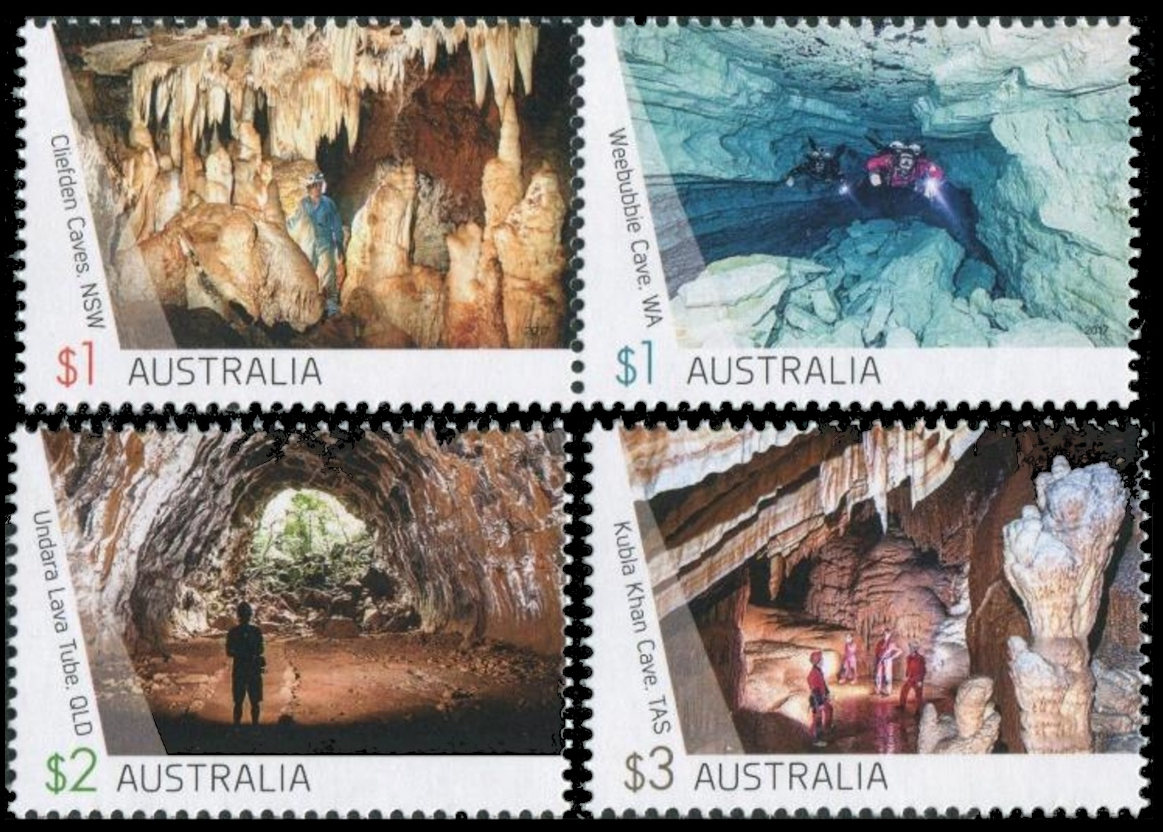
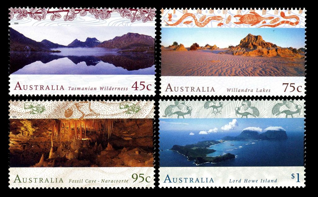
Australia:
Cliefden Caves

|
|
Cliefden Cave on stamp of Australia 2017
|
The Cliefden Caves Geoheritage Site is multifaceted, containing internationally
significant
Ordovician fossil localities,
limestone caves of national significance, a warm spring and tufa dams
of state significance and the historically significant site where
limestone was first discovered in inland Australia.
It has been ranked among the 70 most significant fossil sites in Australia by the
Australian Heritage Council and as the thirteenth most significant
limestone cave site in Australia by Davey.
The site was nominated to the Register of the National Estate by the Geological Society of
Australia in the late 1970s and registered in
1987.
[R5]
Known Philatelic items:
commemorative stamp from "
Caves" set of Australia 2017, MiNr.: 4625, Scott: 4619a.
Australia:
Lord Howe Island

|

|
|
Lord Howe Island on stamps of Australia 1996 and 2007
|
Rocks and land at the foot of these mountains is calcarenite, a coral
sand, blown inland during the Pleistocene between 130,000 and 20,000
years ago and cemented into stratified layers by water percolation.
In this rock are fossils of bird bones and eggs, land and marine snails
and the extinct endemic horned turtle (
Meiolania platyceps) now thought
to be an ancient relict non-swimming tortoise with relatives in South America.
[R6]
Known Philatelic items:
Australia:
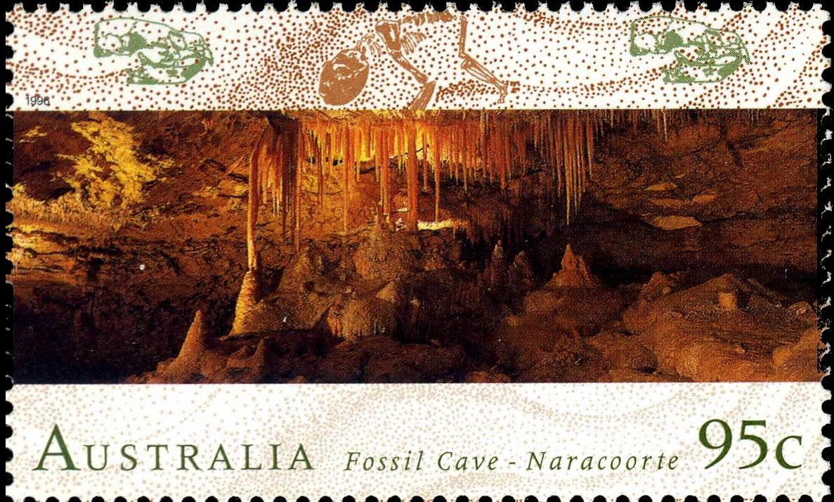
Naracoorte Caves National Park - Victoria Fossil Cave
Naracoorte Caves is a national park near Naracoorte in the Limestone Coast
tourism region in the south-east of South Australia.
It was officially recognised in
1994 for its extensive
fossil record when the site was inscribed on the World Heritage List, along with Riversleigh.
The park preserves 6 km of remnant vegetation, with 26 caves contained within the 3.05 km
World Heritage Area.
 |
|
Maxi Card of Australia 1996 with landscape of Fossil Cave - Naracoorte.
|
The limestone of the area was formed from coral and marine creatures 200 million years ago
and again 20 million years ago when the land was below sea level.
Ground water since then has dissolved and eroded some of the limestone, creating the caves.
The caves, such as the Victoria Fossil Cave and Blanche Cave, are often not far below ground, and holes
open up creating traps for the unwary.
This is the source of the remarkable collection of fossils.
Mammals and other land creatures have fallen into open caves and been unable to escape.
The fossil record has been preserved in strata formed from eroded topsoil washed and blown in.
In some places, the fossil-bearing silt is up to 20 metres thick.
Some of these areas are being preserved for future research when better methods of
dating and reconstructing fossil records may have been found.
These fossil traps are especially significant for tracing Australian megafauna.
Palaeontology is a familiar activity at the Naracoorte Caves World Heritage Area.
The first published account of fossils from this site was in 1858 by Father Julian Tenison Woods.
Following the discovery of Main Fossil Chamber, Victoria Fossil Cave in 1969, science was firmly
established at the site.
Paleontological research has led to the discovery of 23 fossil deposits in 13 of the Park’s 28 caves and
over 60 scientific papers, 17 student theses, numerous book chapters, and other publications.
[R4]
Known Philatelic items:
commemorative
stamp of Australia 1994,
MiNr.: 1538, Scott: 1487 (the same stamp as used for the Maxi Card above) - some stylized fossils depicetd on the top of the stamp.
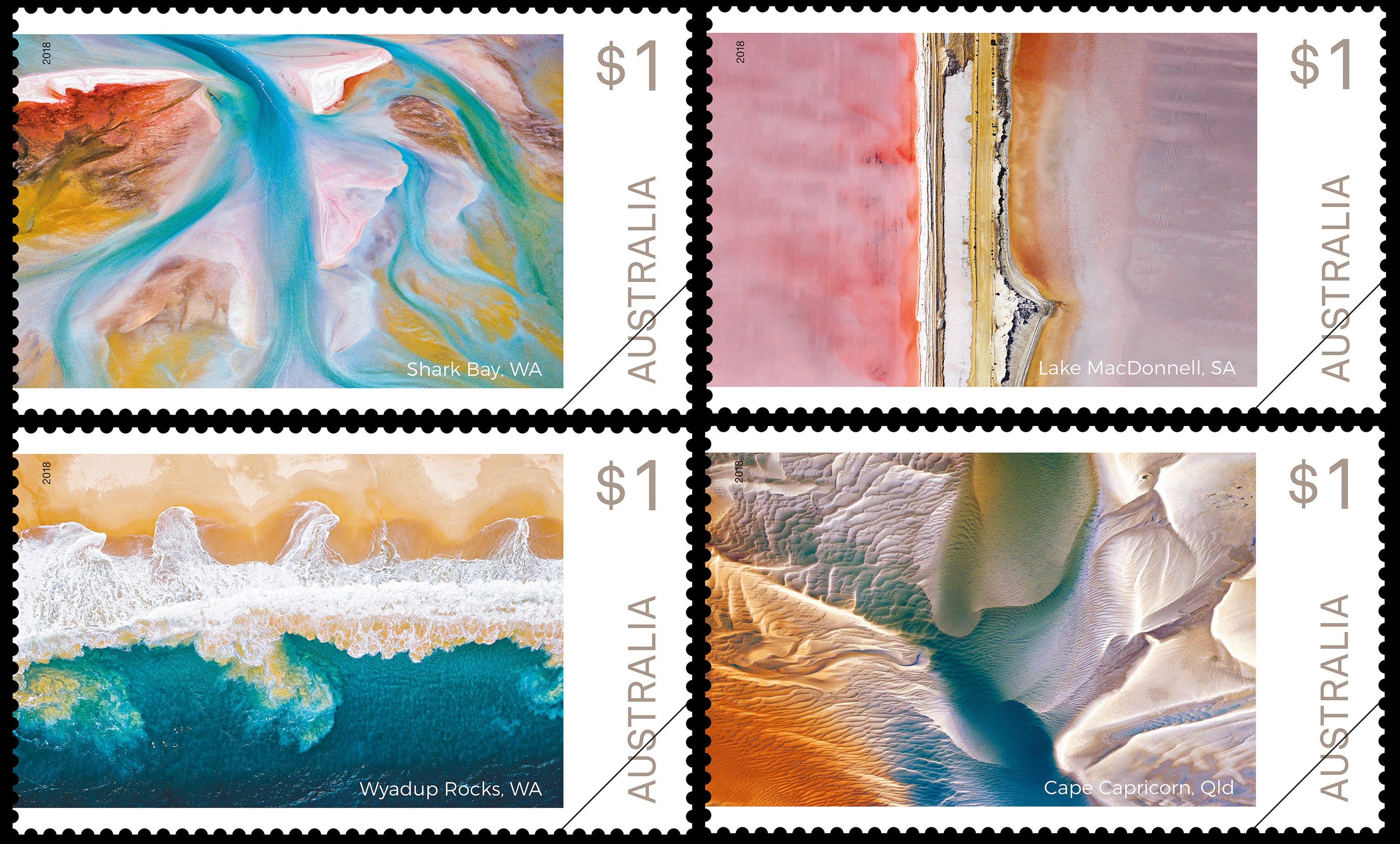
Australia:
Shark bay

|

|
|
Shark Bay on stamp of Australia 1993 and 2018 |
 |
|
Stromatolite Shark Bay. The image is from
Wikipedia
|
Shark bay is a World Heritage Site in the Gascoyne region of Western Australia.
The bay located about half way up Western Australia's west coast, stretches along 1,500 kilometres
of coastline.
It includes several islands, white sand beaches, red cliffs and tranquil turquoise lagoons and
is home to remarkable biological diversity and marine life.
Shark Bay is also one of the few places where scientists can study
modern
stromatolites – a bacterial-sediment structure.
Based on growth rate it is believed that about 1,000 years ago
cyanobacteria (blue-green algae) began building up stromatolites in
Hamelin Pool at the Hamelin Station reserve in the southern part of the bay.
These structures are modern equivalents of the earliest signs of
life on Earth, with fossilized stromatolites being found dating from
3.5 billion years ago at North Pole near Marble Bar, in Western
Australia, and are considered the longest continuing biological lineage.
Stromatolites make-up the majority of
fossils from the Precambrian.
They were first identified in 1956 at Hamelin Pool as a living
species[dubious – discuss], before that only being known in the
fossil record.
Hamelin Pool contains the most diverse and abundant examples of living
stromatolite
forms in the world. Other occurrences are found at Lake Clifton near Mandurah
and Lake Thetis near Cervantes. It is hypothesized that some
stromatolites contain a new form of chlorophyll -
chlorophyll f.
[R7]
Known Philatelic items:
Australia:
Willandra Lakes

|
|
Willandra Lakes on stamp of Australia 1996
|
Willandra contains some of the earliest evidence of
Homo sapiens sapiens outside Africa.
The evidence of occupation establishes that humans had dispersed as far as Australia by 42,000 years ago.
Sites also illustrate human burials that are of great antiquity, such as a cremation dating to around
40,000 years BP, the oldest ritual cremation site in the world, and traces of complex plant-food gathering
systems that date back 18,000 years BP associated with grindstones to produce flour from wild grass
seeds, at much the same time as their use in the Middle East.
Pigments were transported to these lakeshores before 42,000 years BP.
Evidence from this region has allowed the typology of early Australian stone tools to be defined.
[R8]
Known Philatelic items:
commemorative stamp from "
Australian World Heritage Sites" set of Australia 1996,
MiNr.: 1537, Scott: 1486 (see above).
Bolivia:
Chuquisaca , is a department of Bolivia located in the center south.
It borders on the departments of Cochabamba, Tarija, Potosí, and Santa Cruz.
The departmental capital is Sucre, which is also the constitutional capital of Bolivia.
Many
dinosaur footprints are found there.
[R9]
The footprints and dinosaurs who left these footprints are depicted on the stamps issued in
1997 and 2012.
They were also used in the illustration for the 2007 Tourism, Tourist destinations,
Tourist Departments – Chuquisaca” issue.
 |
 |
 |
|
Dinosaur's footprint on FDC's cachet for "Tourism, tourist destinations, Tourist Departments - Chuquisaca" stamps issueof Bolivia 2007.
|
The footprints and dinosaurs who left these footprints are depicted on the stamps issued in 1997 and 2012.
|
Known Philatelic items:
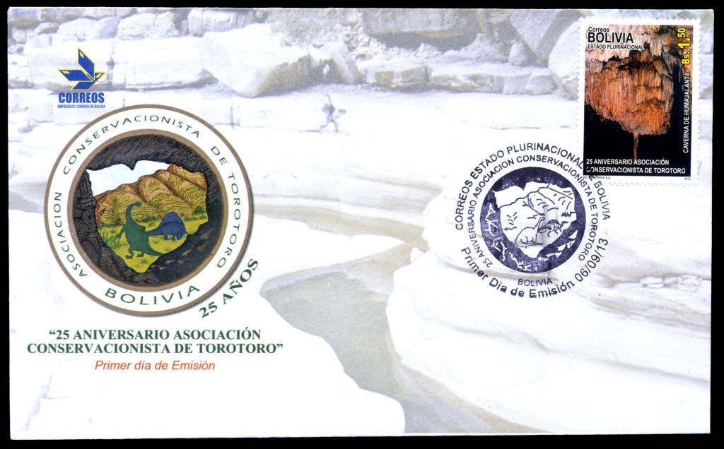
Bolivia:
The Conservation League Torotoro (ACT)
 |
 |
|
Landscape of the Conservation League Torotoro on stamp of Bolivia 2013.
MiNr.:, Scott: and the postmark from its FDC.
|
The Conservation League Torotoro (ACT), was founded on June 10, 1988, in order to
promote the conservation, protection and proper management of flora and fauna,
paleontological and speleological
resources and natural beauty of the area Torotoro.
Some
dinosaurs are depicting on
FDC and commemorative postmark.
[R10]
Known Philatelic items:
Brazil:
Lagoa Santa

|
|
One of the caves at Lagoa Santa on the cashet of FDC of Brazil 2010
|
In 1835 Danish
paleontologist Peter Lund decided to
settle in Lagoa Santa, in the state of Minas Gerais, Brazil, finding the perfect
place to live quietly and develop his work.
In nine years of research he explored more than a hundred caves, and found about 120 fossil species and
94 belonging to the current fauna.
He thus became the Father of Brazilian Paleontology.
These findings were of great importance for the studies undertaken by British naturalist
Charles Darwin on the Theory of Evolution.
In 1844, Lund ended his work in the cave, and took a new direction in his research.
In 1845, he sent his magnificient collection to the University of Copenhagen in Denmark and then devoted himself to
botany.
Currently this rich colection is at the Zoological Museum in Copenhagen.
[R11]
Known Philatelic items:
- cachet of FDC with stamp dedicated to "Peter Lund",
Brazil 2010.
 |
|
Fossil site: Joggins Fossil Cliffs on stamp of Canada 2014
MiNr.:, Scott:
|
Canada:
Joggins Fossil Cliffs
Nearly 200 fossil species found in the
Joggins Fossil Cliffs
reveal the world’s most complete record of terrestrial life from the Pennsylvanian Period
(the Coal Age), over 300 million years ago.
It is possible to find here some of the earliest fossilized reptiles.
These reptiles were some of the earliest amniotes, animals that lay shelled eggs –
that allowed reptiles to lay eggs away from water.
[R12]
Known Philatelic items:

|
|
Fossil site: Miguasha National Park on stamp of Canada 2014
MiNr.:, Scott:
|
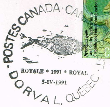
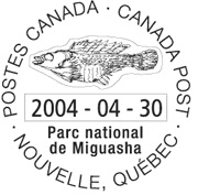
Canada:
Miguasha National Park
Nearly 400 million years ago, today’s
Miguasha National Park,
Quebec(right) on the Gaspé Peninsula was once a tropical estuary.
The fossil beds of the Escuminac Formation, exposed in a seaside cliff provide a rare portrait
of Devonian life – including 21 species of fish fossils that have made Miguasha famous.
[R13]
Known Philatelic items:
- stamp from "UNESCO World Heritage Sites" set of
Canada 2014. Mint/Self-adhesive stamp: MiNr.: 3076/3081 Scott: 2718e/2722.
- Commemorative postmarks of Canada
1991,
2004 shows fossils of some prehostoric fishes, discovered in the Park.
Canada:
Dinosaur Provincial Park
Dinosaur Provincial Park in the badlands of southeastern Alberta, contains some of the most important fossil
discoveries of more than 40 dinosaur species dating back to the Late Cretaceous Period,
75 million years ago.
 |
|
Fossil site: Dinosaur Provincial Park, Alberta, Canada on stamp of Canada 2015
MiNr.:, Scott:
|
The families
Hadrasauridae,
Ornithomimidae,
Tyrannosauridae,
Nodosauridae,
Pachycephalosauridae and
Ceratopsidae are best represented.
Other fossil remains include fish, turtles, marsupials and amphibians.
The retreat of the last ice age about 13,000 years ago created the Red Deer River Valley,
along with the
hoodoos, isolated mesas and low-lying coulees of the badlands.
It also left the Earth’s greatest concentration of Late Cretaceous dinosaur fossils.
Since digging began in the 1880s, more than 300 dinosaur skeletons have been pulled from a 27-kilometre stretch along the Red
Deer River.
These remains can be found in museums around the world, but mostly in
Royal Tyrrell Museum.
[R14]
Known Philatelic items:
- stamp from "Scenic Highways" set of
Canada 1998, MiNr.: 1694, Scott: 1740
- stamp from "UNESCO World Heritage Sites" set of
Canada 2015. Mint/Self-adhesive stamp: MiNr.: 3289/3290, Scott: 2857a/2858.
- stamp from "UNESCO World Heritage Sites" set of Canada 2017. Mint/Self-adhesive stamp: MiNr.: 3442/3447 Scott: 2963a/2964 .
Canada:
Mistaken Point
 |
|
Fossil site: Mistaken Point on stamp of Canada 2017
MiNr.:, Scott:
|
At Mistaken Point, the rugged coastal
cliffs host the oldest known
collection of large fossils in the world,
marking the world’s first appearance of large, biologically complex organisms,
of the primitive animals of the Ediacaran fauna.
The Ediacaran fauna includes the first large,
biologically complex organisms that may be related to animals.
[R15]
Known Philatelic items:
- stamp from "UNESCO World Heritage Sites" set of Canada 2017. Mint/Self-adhesive stamp: MiNr.: 3443/3448 Scott: 2963b/2967 .
Colombia:
The Tatacoa Desert
The Tatacoa Desert (Deserto de la Tatacoa) that depicting on
one of the stamps is the second largest arid zone in Colombia after the Guajira Peninsula.
The Tatacoa is not really a desert, but rather a dry tropical forest ecosystem.
It occupies 330 square kilometers of land.
This semiarid region is located north of Huila Department, 38 km from the
city of Neiva in Colombia and 15 km from Natagaima in Tolima.
It is a rich deposit of
fossils and is a great tourist destination.

|
|
Tatacoa Desert on stamp of Colombia 2003,
|
La Tatacoa is considered one of
the largest vertebrate fossil sites of America,
thanks to the evolution of its earth layers and to the conditions that have facilitated the
accumulation of specimens that represent prolonged periods, allowing
for characterization of chronological units with fauna inherent to the
geological evolution of the Cenozoic period.
It is the most varied paleontological record for the Miocene and Pleistocene in Colombia and
in the continent.
The most recognized fossil sites due to the wealth and importance of the American fauna found there are located in
the Cerro Gordo or El Dinde, the basin of La Venta creek and Los Micos or El Cusca.
The special characteristics of this region´s fossil have led to studies carried out by various research institutions
in Colombia, the United States and Japan.
The area´s paleontological wealth has been recorded in a publication from the Smithsonian Institution of Washington,
totally dedicated to the fossil fauna of La Venta.
[R16]
Known Philatelic items:
- stamp from "Department of Colombia: Huila" set of Colombia 2003 (see on the right).
MiNr.: 2252, Scott: 1205g.
Czech Republic:
Skryje village
Skryje is a village in the Central Bohemian Region of the Czech Republic.
 |
|
Křivoklátsko Protected Landscape Area on stamps of
Czech Republic 2013.
|
 |
|
Trilobites from Skryje on pstmark of Czech Republic 2013.
|
It lies upon the Berounka River, some 50 km to the west from the country capital Prague,
within
Křivoklátsko Protected Landscape Area.
Křivoklátsko Protected Landscape Area,
is a protected landscape area in the Czech Republic.
Most of the area belongs to the highlands of the Křivoklát Highlands
and lies on both banks of the Berounka river.
In 1978 the Landscape Area was included among the UNESCO Biosphere reserves.
This little village became famous when French geologist and
palaeontologist
Joachim Barrande discovered
rich fossil deposits of Silurian fauna (namely trilobites) in the close surroundings of this village,
when he was surveying the terrain for a horse-pulled railroad in 1840–1850.
Some of the trilobites were depicted on commemorative postmarks used on
one FDC of
the "Nature Protection - The Krivoklatsko Region - A UNESCO Biosphere - Eudia pavonia Reserve" stamps set.
Today there's a small museum in the Municipal Office building showing some of his finds.
[R17]
Known Philatelic items:
Czech Republic:
Iron Mountains
Iron Mountains are the key to geological history of central Europe.
Proterozoic gneisses and volcano sedimentary complexes (subaerial and submarine volcanism) are present.
The earliest life forms have been found – stromatolites.
 |
 |
|
The landscape of Iron Mountains on stamp of Czech Republic 2016.
An Ammonite from Iron Mountains on postmark of Tremosnice town, from FDC of Czech Republic 2016.
|
The Paleozoic comprises Cambrian siltstones,
Ordovi cian quartzites, Silurian shales, Devonian limestones and Carboniferous sediments.
Rare fossils include trilobite and graptolite fauna.
The third oldest ichnofossil of Zoophycos type in the world has been reported from this locality.
The Mesozoic (Upper Cretaceous) sedimentary cover has a unique development, with abundant fauna and flora.
Sandstones and spiculitic marlstones provide excellent conditions for groundwater accumulation.
Tertiary rocks are represented by basalt enclosing olivine-rich xenoliths.
Geological story of the area is completed by Quaternary loess and sandy gravel.
Over a hundred geosites have been described from this area.
The above facts became grounds for listing the Iron Mountains as a National Geopark.
[R18]
Known Philatelic items:
- stamp of Czech Republic 2016, MiNr.: 903, Scott: 3687(see above).
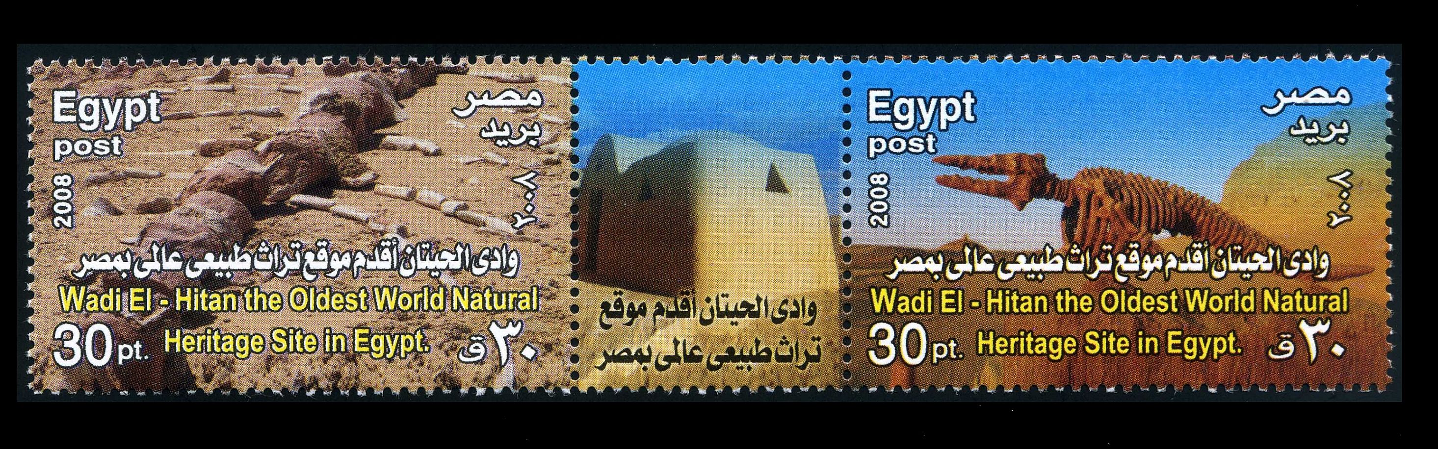
Egypt:
Wadi Al-Hitan, Whale Valley,
in the Western Desert of Egypt
is a paleontological site in the Al Fayyum Governorate of
Egypt, some 150 km southwest of Cairo.
 |
|
Fossils of prehistoric whales from Wadi Al-Hitan on FDC of Egypt 2008.
|
It was designated a UNESCO World Heritage Site in July 2005 for itsc hundreds of fossils of some of the
earliest forms of whale, the archaeoceti (a now extinct sub-order of
whales). The site reveals evidence for the explanation of one of the
greatest mysteries of the evolution of whales: the emergence of the whale
as an ocean-going mammal from a previous life as a land-based animal. No
other place in the world yields the number, concentration and quality of
such fossils, as is their accessibility and setting in an attractive and
protected landscape. This is why it was added by the UNESCO to the list of
protected World Heritage sites.
The fossils found at the site may not be the oldest but
their great concentration in the area and the degree of their preservation
is to the extent that even some stomach contents are intact. The presence
of fossils of other early animals such as sharks, crocodiles, sawfish,
turtles and rays found at Wadi El-Hitan makes it possible to reconstruct
the surrounding environmental and ecological conditions of the time,
adding to its justification to be cited as a Heritage
site.
The first fossil skeletons of whales were discovered in the
winter of 1902-3.For the next 80 years they attracted relatively little
interest, largely due to the difficulty of reaching the area. In the 1980s
interest in the site resumed as four wheel drive vehicles became more
readily available. Continuing interest coincided with the site being
visited by fossil collectors, and many bones were removed, prompting calls
for the site to be conserved. The remains display the typical streamlined
body form of modern whales, yet retaining some of the primitive aspects of
skull and tooth structure. The largest skeleton found reached up to 21 m
in length, with well-developed five-fingered flippers on the forelimbs and
the unexpected presence of hind legs, feet, and toes, not known previously
in any archaeoceti.
Their form was serpentine and they were carnivorous. A few
of these skeletal remains are exposed but most are shallowly buried in
sediments, slowly uncovered by erosion. Wadi El-Hitan provides evidences
of millions of years of coastal marine life.
[R19]
 Color variation of Wadi El-Hitan stamp of Egypt 2008
Known Philatelic items:
France:
Domérat
Domérat is a French commune located in the department of Allier, in the Auvergne-Rhône-Alpes region.
 |
 |
|
Landscape of Domerat commune on postmark and meterfranking France.
|
A fossiliferous deposit was discovered at Domérat, in a pocket of green clay
(interstratified smectite-illite).
It is chaotic accumulation of teeth and bone fragments from large mammals covered
by deposits of coarse quartz gravel.
The broken up nature of the bones and the coarse gravel suggest transport by
high-energy currents and down slope flow.
The Montluçon-Domérat Basin is a relatively depressed area, about 15 km long from north to south,
with a generally semi-circular western side and abutting against a well-developed NS escarpment,
the Cher fault, to the east. Geometric considerations (outcrop locations, borehole intersections)
show the Cenozoic deposits to be 100 m or thicker in the deepest part of the basin, the Cher Trench.
Most of the basin filling is composed of monotonous clayey-sandy deposits showing no stratification,
but in places containing coarse sub-rounded quartz gravel.
Fossils of several prehistoric mammals have been found there:
Palaeotherium magnum,
Palaeotherium sp.,
Plagiolophus minor Anoplotherium commune,
Xiphodon gracile,
Amphimeryx sp. and more.
[R27]
Known Philatelic items:
- tourist office, postmark of France 2000 (see above)
- tourist office, meterfranking of France 2008 (see above)
France:
Géologique de Haute-Provence National Nature Reserve
 |
|
Fossil of Ichthyosaurs from Géologique de Haute-Provence National Nature Reserve on postmark France 1990
|
The Géologique de Haute-Provence National Nature Reserve is a national nature
reserve in Provence-Alpes-Côte d'Azur.
Established in 1984, it covers 269.316 hectares over 18 sites in the Alpes-de-Haute-Provence and Var.
Located between the Verdon and Durance rivers, it is a labellised area for its landscape diversity,
witness of the geological past of the Earth.
It is the largest geological reserve in Europe.
Many fossils were found in the Reserve, icluding genus of primitive ichthyosaur
Suevoleviathan from
La Robine. The fossil can be seen in the Digne museum.
The genus Suevoleviathan probably reached a total length of up to 4 meters.
Suevoleviathan was unique among ichthyosaurs in that it retained relatively large forefins.
The ichthyosaur lived during the late Toarcian, 185 millions of years ago.
This marine reptile was quickly buried, which limited its decomposition.
Its conservation is due to paleogeographic conditions favouring the tilting of blocks,
caused by the rifting following the opening of the Piemont-Liguria Ocean.
Another famous fossils of the Reserve are the Dalle à ammonites from the north of Digne-les-Bains.
With a 60° incline, it bears over 1 500 ammonites, 90% of which belonging to the species
Coroniceras multicostatum from the Sinemurian (Early Jurassic).
Those ammonites could attain a diameter of 70 cm.
[R21]
Known Philatelic items:
- landscape postmark of France 1998-2008.
Three major varieties of this postmark were produced with different locations, changes in the font and text, and the year when used.
- Digne Les Bains CTA
- Digne Les Bains CTC
- Digne Les Bains R.P. (see above)
France:
The National Natural Reserve of Hettange-Grande
 |
 |
|
Hettange-Grande town on postmark France 1987-1988 and 1989-2008
|
Hettange-Grande is a commune in the Moselle department in Grand Est in north-eastern France.
The town gives its name to the Hettangian age, the earliest age of the Jurassic period of the geologic
timescale, the time between 201 and 199 million years ago.
The National Natural Reserve of Hettange-Grande was created in 1985 in order to protect a unversal geological
heritage site.
The Hettange-Grande National Natural Geological Reserve is one of eleven geological reserves in France and
the only one in Lorraine region of France.
The site is also a protected area for many animals, birds, reptiles, bats and insects.
[R21]
Known Philatelic items:
- tourist office, postmark with Ammonite, was in use between 1987 and 1988 (see on the top)
- tourist office, postmark with some marine fossils, was in use between 1989 and 2008 (see on the top)
France:
Menat
Menat is a commune in the Puy-de-Dôme department in Auvergne-Rhône-Alpes in central France.
It is in the heart of the valley of Sioule.
 |
|
Landscape of Menat city on postmark France 1986
|
Menat is a unique paleontological site in Europe which testifies to 56 million years
of plant and animal life, well before the appearance of man.
Many fossils have been discovered extracted from the shales.
A dedicated museum was inaugurated in 1980 and housed in the former abbey castle (now town hall).
Paleocene bird fossils have been discovered in Menat, including
Halcyornithidae,
Messelasturidae, and relatives of Songziidae.
[R25]
Known Philatelic items:
- landscape postmark of France 1986 (see above).
France:
Nolay
Nolay is the capital of a canton in the Côte-d'Or department in eastern France.
 |
|
Landscape of Nolay town and Ammonite on postmark France 1990
|
This region is dominated by agriculture, tourism, and industry.
The town marks the transition between the forests and plains to the north and west and
the hillside vineyards of the wealthy Burgundian wine regions surrounding Beaune and the
Chalonnaise hills to the south.
There are some sediments of Triassic age, are around the town.
Many Ammonites can be found there.
[R24]
Known Philatelic items:
- landscape postmark of France 1989-2008 (see above).
France:
Privas
Privas is a commune of France, capital of the Ardèche department.
It is the smallest and the least populated administrative centre of any department in France.
 |
|
Landscape of Privas commune on postmark France 2001.
|
Privas commune is also a noted area for fossils.
[R26]
Known Philatelic items:
- Landscape of Privas commune on postmark France 2001 (see above).
France:
Toarcien National Nature Reserve
 |
|
Landscape of Thouars town on postmark France 1989
|
The Toarcien National Nature Reserve is a French national nature reserve located in Nouvelle-Aquitaine,
near the city of Thouars, from which the name Toarcian is derived.
Established in 1987, it occupies an area of 0.61 hectares, making it the smallest national nature reserve
in France.
It protects two former quarries preserving the stratotype of the Toarcian stage.
It bears the stratotype of the Toarcian, the latest stage of the Early Jurassic.
The Toarcian stage is divided in 34 elementary units or "horizons". Each horizon correspond to
a period of approximately 260 000 years, and is characterized by one or several specific ammonite species.
[R23]
Known Philatelic items:
- landscape postmark of France 1989-2008 (see above).
France:
Villers-sur-Mer
located on the Normandy coast between Dives-sur-Mer and Villers-sur-Mer,
the Vaches Noires are made up of cliffs that can reach 110 m in height.
 |
 |
|
Touristis, landscape postmark of Villers-sur-Mer, with an Ammonite, France 1969-2005
|
They are located in the municipalities of Dives-sur-Mer, Houlgate, Auberville
and Villers-sur-Mer (from west to east), near Cabourg and Deauville/Trouville, in Calvados.
The coastline around the town of Villers-sur-Mer is full of the fascinating remains of Normandy’s
prehistoric past, and this is symbolised by the gigantic plant sculpture of a dinosaur opposite the
tourist office as you enter the town.
The paleontological site of the Vaches Noires cliffs between Villers-sur-Mer and Houlgate has been
scientifically recognised for its million years of history.
This location is well known in France for the many fossils found there.
The fossils include both marine fossils such as ammonites and
Ichthyosaurus and terrestrial animals
like dinosaurs.
Normandy’s biggest carnivores and herbivores dinosaurs like
Streptospondylus,
Lexovisaurus d’Argences and
Dubreuillosaurus valesdunensis of Conteville are displayed
under theatrical lighting with other Jurassic fauna
at "Paleospace" museum, that opened its doors in 2011.
[R20]
Known Philatelic items:
- permanent, tourist office, postmark with Ammonite, was in use between 1969 and 2005 (see above).
- tourist office postmark with stylized sauropod dinosaur of France from 2004 (see above).
Germany:
The Messel Pit (German: Grube Messel)

The Messel Pit is a disused quarry near the village of Messel,
about 35 km southeast of Frankfurt am Main, Germany.
Messel Pit was declared a UNESCO World Heritage site on 9 December 1995, due to many fossils with
significant geological and scientific importance found there.
The Messel Pit provides many very well preserved fossils of Eocene flora and fauna
(56 to 33.9 million years ago), sometimes even with "skin shadows".
Several species were commemorated on German stamps: prehistoric bat (
Palaeochiropteryx)
and prehistoric horse (
Propalaeotherium) in 1978,
prehistoric crocodile (
Diplocynodon) in 1998.
There are also several German postmarks that shows similar fossils and the landscape of
Messel Pit.
Known Philatelic items:
- postmark of Germany 1998, from Berlin and Bonn cities, used on FDC with the prehistoric crocodile stamp (see above).
Germany:
The Dechen cave (German:
Dechenhöhle)

|

|
|
The entrance to the Dechen cave and fossil of Cave Bear from the Dechen cave on commemorative postmarks of Germany 2018
|
The Dechen Cave (German: Dechenhoehle) in Iserlohn, Germany is one of the most visited show caves in Germany.
It is located in the northern part of the Sauerland at Iserlohn (Grüne district).
360 metres of the 870-metre long cave have been laid out for visitors, beginning at the spot where, in 1868,
the cave was discovered by two railway workers.
The workers dropped a hammer into a rock crevice which turned out to be the entrance to a dripstone cave
when they were searching for the lost tool.
The cave is named after Chief Captain Heinrich von Dechen (1800–1889), in recognition of his contribution
to researching the geology of the Rhineland and Westphalia.
Fossils of many prehistoric mammals were discovered in the cave, since 1910, including.
Cave Bear (
Ursus spelaeus), Wolly Rhino (
Coelodonta antiquitatis),
Cave Lion (
Panthera leo spelaea),
Known Philatelic items:
- two postmarks "150th anniversary of Dechen cave discovery" (see above) of Germany 2018.
One show the entrance to the Dechen cave. Another one show a skeleton of Cave Bear discovered in the cave.
- cachet of commemorative postal stationery "150th anniversary of Dechen cave discovery" of Germany 2018.
Italy :
Dunarobba fossil forest nearby Avigliano Umbro
The Dunarobba fossil forest nearby Avigliano Umbro, has
been discovered in the 70s, but the work to bring it up to surface are not
yet finished. All the trees belong to a family of sequoia which used to
be present in this part of italy more than one million years ago. The
particularity with this forest is that the trees lay in vertical position
and not horizantally as it is the case for other fossil forests. This
would confirm the theory that a flood could have overwhelmed the forest
preserving it in the shape we admire today. The fossiles have enormous
dimensions: 1.5 m in diameter and between 5 and 10 meters in high.
Vietnam :
"
Dong Van Karst Plateau Geopark" recognized by UNESCO on October 3, 2010.
It became the first Global Geopark in Vietnam, and the second one in Southeast Asia.
 |
|
Landscape of Dong Van Karst Plateau UNESCO Geopark on stamp of Vietnam 2021.
|
 |
|
Landscape of Dong Van Karst Plateau UNESCO Geopark on stamp of Vietnam 2021.
|
This Geopark is located in the northernmost mountainous region of Vietnam, with an area of 2,356.8 km
2 and the average altitude
is about 1,400 meters - 1,600 meters.
Up to 60% of the area of this geopark is covered by karst, thus, it is the largest karst area in comparison with oth-
er regions of Vietnam.
The Geopark is located in an extension of the foothills of the eastern Himalayas, where Vietnam shares a
border with China in the north.
The Plateau has areas of steeply sloping limestone mountains.
It is located near the Tropic of Cancer.
The geologic units found in the park range from the Cambrian (550 million years ago) to the Cenozoic.
Local geologists describe seven different stages across the region which include:
- Cambrian-Early Ordovician – shales and limestones deposited in a tectonically-quiet, shallow marine
environment.
- Middle Ordovician-Silurian – absent in the Park, but present in other parts of Northern Vietnam.
The regional geology suggests that small mountain ranges developed in this area separated by basins
in which sediment was deposited.
- Devonian-Early Carboniferous – these rocks lie unconformably on top of eroded older rocks.
They consist of calcareous siltstones, shales, and sandstones deposited in shallow marine conditions.
These rocks are highly fossiliferous with common fossils including fish, brachiopods, gastropods, and ostracods.
The Late Devonian-early Carboniferous interval is dominated by limestones and black shales suggesting that water depth deepened in this region.
- Early Carboniferous – Middle Permian rocks in the region are dominated by dolomites
and limestones with open marine fossils including foraminifers, corals, and brachiopods.
- Late Permian – Early Triassic include Permian limestones overlain by a continental sequence of conglomerates,
sandstones, siltstones, and shales of the Triassic.
- Jurassic-Cretaceous – not exposed in the Park, but extensive volcanic activity occurred across northern Vietnam during this interval.
- Cenozoic – the Cenozoic was the most important stage in developing the modern topography in the park.
The slow movement of India north built the Himalayas, southeastern Asia responded to this collision by reactivation of
older faults causing uplift of the limestone rocks to the surface.
As the modern Monsoonal climate developed, the humid conditions caused partial dissolution of the limestone developing the karst terrain at this site.
The regional center in Dong Van district includes a museum, which has a collection of regional
rocks,
fossils, publications about the geopark and historical antiques of local people
living in the Dong Van Karst Plateau.
The Dong Van Karst Plateau is highly rated by scientists for its geoscientific values, unique in the world,
with many manifestations of geoheritage that have been formed throughout the last 540 million years.
19 fossil groups have been found in the Geopark, including
500 million old trilobite.
[R28]
Known Philatelic items:
Vietnam :
“
Non Nuoc Cao Bang Geopark”
[R2]: recognized by UNESCO on April 12, 2018.
 |
|
Landscape of Non Nuoc Cao Bang UNESCO Geopark on stamp of Vietnam 2021.
|
The Geopark covers more than 3,275 square kilometers located in the frontier area of Vietnam named Cao Bang,
including areas of Ha Quang, Tra Linh, Quang Uyen, Trung Khanh, Ha Lang, and Phuc Hoa districts and part
of Hoa An, Nguyen Binh and Thach An districts.
It is home to more than 250,000 people belonging to 9 ethnic groups of Vietnam such as
Tay, Nung, H'Mong, Kinh, Dao, and San Chay ethnic groups.
In addition, it is also a rich cultural and historical land with more than 215 ranked cultural and
historical relics, including 3 National Monuments, especially Tran Hung Dao Forest, Pac Bo historic
site and the historic site of Border Victory in 1950.
It is one of the areas in Vietnam occupied since prehistoric time with evidence of occupation
going back 20,000 years.
This region hosted the ancient capital of several feudal dynasties and was the cradle of the
Vietnamese Revolution from the French war.
The western part features sedimentary rocks, pillow basalts, ultra-mafic and granitic intrusions rich in
minerals and hydrothermal alterations.
The area also reveals sedimentary rocks dating back more than 500 million years, with stratotype cross-sections,
and fossils indicating different paleo-environments and biosphere extinction events.
The diversity of rocks (stratigraphy, paleontology, paleoenvironment, petrology, mineralogy etc.)
and landforms (tectonics, geomorphology, karst, weathering, soil erosion etc.) are evidence of the geodiversity
of the area, each with its own characteristic of different evolutionary stages of the Earth’s crust.
[R29]
Known Philatelic items:
Vietnam :
“
Dak Nong Geopark”
[R3]: recognized by UNESCO on July 7, 2020.
 |
|
Landscape of Dak Nong UNESCO Geopark on stamp of Vietnam 2021.
|
The Geopark covers an area of 4,760 km
2 with 5 districts: Krong No, Cu Jut, Dak Mil, Dak Song,
Dak Glong and Gia Nghia city in Dak Nong province.
With about 65 geological and geomorphological heritage sites, including an ecosystem of nearly 50 caves with
a total length of more than 10,000 meters, craters, waterfalls...
Dak Nong Geopark is popular as a rich red land with a tropical forest ecosystem
preserving a diverse biota and many and many unique cultural, geological, and natural features as well as
vestiges of activities of the
prehistoric man.
Its history begins 140 million years ago when an ocean was covering this area.
Limestone, ammonites and various fossils are the silent witnesses of this marine past.
Lava from volcanic eruptions has partially covered this land. Rich and fertile red soils have formed from the basaltic lava rocks.
Since 10,000 years ago, volcanoes were still active in this area, creating the most unique and massive volcanic cave
system in Southeast Asia.
Especially, traces of prehistoric man's habitation dating back tens of thousands of years have been
found in these caves.
[R30]
Known Philatelic items:
References:
- [R1] Jamala island, Aland:
Fossil.net,
The Fossil Forum.
- [R2] Bosques Petrificados Natural Park:
Wikipedia
- [R3] Ischigualasto / Talampaya Natural Parks:
UNESCO,
Wikipedia
-
[R4] Naracoorte cave: environment.sa.gov.au
Australian Museum,
The University of Adelaide,
-
[R5] Cliefden Caves: Wikipedia
-
[R6] Lord Howe Island: Wikipedia
-
[R7] Shark Bay:
official site,
ABC Science,
Wikipedia
-
[R8] Willandra Lakes Regionon:
Wikipedia
- [R9] Chuquisaca, Bolivia :
Cal Orck'o (Wikipedia),
Bolivia Travel Site
- [R10] The Conservation League Torotoro, Bolivia :
UNESCO,
myfossil.org,
- [R11] Lagoa Santa, Brazil :
- [R12] Joggins Fossil Cliffs, Canada :
- [R13] Miguasha National Park, Canada :
- [R14] Dinosaur Provincial Park, Canada :
- [R15] Mistaken Point, Canada :
- [R16] The Tatacoa Desert (Deserto de la Tatacoa) :
Wikipedia,
UNESCO,
La Venta Fauna : Fossil Gallery
- [R17] Skryje village, Czech Republic:
Wikipedia,
Křivoklátsko Protected Landscape Area (Wikipedia).
- [R18] Iron Mountains, Czech Republic:
- [R19] Wadi Al-Hitan, Whale Valley, Egypt:
- [R20] Villers-sur-Mer, France:
fossiles-villers.
- [R21] Geologic Reserve DE LORRAINE, France:
Wikipedia,
tourism-lorraine,
- [R22] Géologique de Haute-Provence National Nature Reserve, France:
Wikipedia,
- [R23] Toarcien National Nature Reserve, France:
Wikipedia
- [R24] Nolay National Nature Reserve, France:
frwiki,
- [R25] Menat city, France:
Wikipedia
- [R26] Privas commune, France:
Wikipedia
- [R27] Domerat commune, France:
Wikipedia (in French),
geolfrance
- [R28] Dong Van Karst Plateau Geopark, Vietnam:
Wikipedia,
"The influence of lithology and tectonics on the development of the karst landscape
in the Dong Van Global Geopark, NE Vietnam", by Manh Ha Doan and Elżbieta Galka. DOI: 10.7494/geotour.2017.50-51.2
- [R29] Non Nuoc Cao Bang Geopark, Vietnam:
UNESCO,
- [R30] Dak Nong Geopark, Vietnam:
UNESCO,
- [R31] Dechen cave, Germany:
Wikipedia,


