Vietnam 2021 "Geoparks of Vietnam"
| Issue Date |
30.10.2021 |
| ID |
Michel:,
Scott:,
Category: Ot
|
| Design |
Mr. Nguyen Du from Vietnam Post,
based on photographs of Ngo Huy Hoa, Nguyen Son Tung, Tran An
|
| Stamps in set |
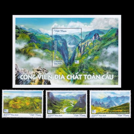
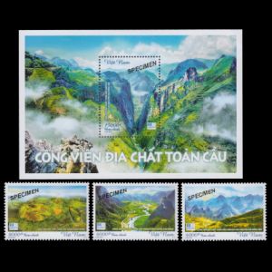
3 + Souvenir-Sheet with 1 stamp |
| Values |
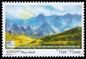
4,000 VND - Đồng Văn Karst Plateau Geopark
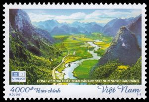
4,000 VND - Non Nước Cao Bằng Geopark
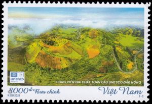
8,000 VND - Đắk Nông Geopark
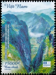
15,000 VND - Đồng Văn Karst Plateau Geopark
|
| Size (width x height) |
stamps: 46mm x 31mm,
Souvenir-Sheet: 120mm x 80mm
|
| Layout |
Souvenir-Sheet with 1 stamp,
3 Sheets of 25 stamps each
|
| Products |
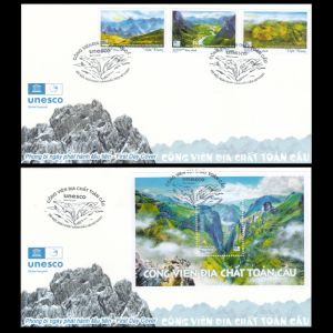
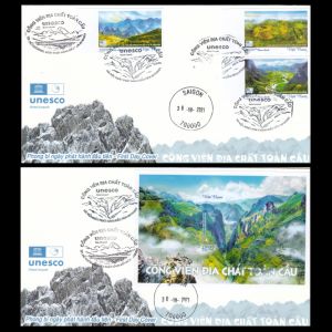
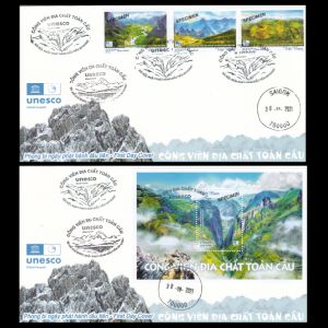
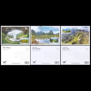
FDCx2, MCx3,
the stamps and the Souvenir-Sheet available as perforated and imperforated variations.
|
| Paper |
|
| Perforation |
13x13 |
| Print Technique |
Offset lithography |
| Printed by |
Post Stamp Printing Company, Vietnam
|
| Quantity |
|
| Issuing Authority |
Vietnam Post (VN Post) - Ministry of Information and Communications (MIC) |
On October 30
th, 2021 the Ministry of Information and Communications of Vietnam issued
the stamp set "Global Geopark" including 3 stamps and a Souvenir-Sheet with 1 stamp.
Global Geoparks are parks recognized by the United Nations UNESCO program as sites with world-class
geology or landscapes that are worth preserving for the enjoyment of everyone.
Geoparks recognize the scientific and educational significance of the site.
They also highlight biodiversity, archaeological, historical, cultural, and societal significances of these sites.
Geoparks work with local communities to develop tourism and support services that benefit the local economy.
Vietnam, has three Global Geoparks recognized by UNESCO:
- Dong Van Karst Plateau UNESCO Global Geopark (Ha Giang) (in 2010);
- Non nuoc Cao Bang UNESCO Global Geopark (in 2018)
- Dak Nong UNESCO Global Geopark (in 2020)
All three parks are famous fossil sites of Vietnam.
"
Dong Van Karst Plateau Geopark"
[R1]: recognized by UNESCO on October 3, 2010.
It became the first Global Geopark in Vietnam, and the second one in Southeast Asia.
 |
|
Landscape of Dong Van Karst Plateau UNESCO Geopark on stamp of Vietnam 2021.
|
 |
|
Landscape of Dong Van Karst Plateau UNESCO Geopark on stamp of Vietnam 2021.
|
This Geopark is located in the northernmost mountainous region of Vietnam, with an area of 2,356.8 km
2 and the average altitude
is about 1,400 meters - 1,600 meters.
Up to 60% of the area of this geopark is covered by karst, thus, it is the largest karst area in comparison with oth-
er regions of Vietnam.
The Geopark is located in an extension of the foothills of the eastern Himalayas, where Vietnam shares a
border with China in the north.
The Plateau has areas of steeply sloping limestone mountains.
It is located near the Tropic of Cancer.
The geologic units found in the park range from the Cambrian (550 million years ago) to the Cenozoic.
Local geologists describe seven different stages across the region which include:
- Cambrian-Early Ordovician – shales and limestones deposited in a tectonically-quiet, shallow marine
environment.
- Middle Ordovician-Silurian – absent in the Park, but present in other parts of Northern Vietnam.
The regional geology suggests that small mountain ranges developed in this area separated by basins
in which sediment was deposited.
- Devonian-Early Carboniferous – these rocks lie unconformably on top of eroded older rocks.
They consist of calcareous siltstones, shales, and sandstones deposited in shallow marine conditions.
These rocks are highly fossiliferous with common fossils including fish, brachiopods, gastropods, and ostracods.
The Late Devonian-early Carboniferous interval is dominated by limestones and black shales suggesting that water depth deepened in this region.
- Early Carboniferous – Middle Permian rocks in the region are dominated by dolomites
and limestones with open marine fossils including foraminifers, corals, and brachiopods.
- Late Permian – Early Triassic include Permian limestones overlain by a continental sequence of conglomerates,
sandstones, siltstones, and shales of the Triassic.
- Jurassic-Cretaceous – not exposed in the Park, but extensive volcanic activity occurred across northern Vietnam during this interval.
- Cenozoic – the Cenozoic was the most important stage in developing the modern topography in the park.
The slow movement of India north built the Himalayas, southeastern Asia responded to this collision by reactivation of
older faults causing uplift of the limestone rocks to the surface.
As the modern Monsoonal climate developed, the humid conditions caused partial dissolution of the limestone developing the karst terrain at this site.
The regional center in Dong Van district includes a museum, which has a collection of regional
rocks,
fossils, publications about the geopark and historical antiques of local people
living in the Dong Van Karst Plateau.
The Dong Van Karst Plateau is highly rated by scientists for its geoscientific values, unique in the world,
with many manifestations of geoheritage that have been formed throughout the last 540 million years.
19 fossil groups have been found in the Geopark, including
500 million old trilobite.
“
Non Nuoc Cao Bang Geopark”
[R2]: recognized by UNESCO on April 12, 2018.
 |
|
Landscape of Non Nuoc Cao Bang UNESCO Geopark on stamp of Vietnam 2021.
|
The Geopark covers more than 3,275 square kilometers located in the frontier area of Vietnam named Cao Bang,
including areas of Ha Quang, Tra Linh, Quang Uyen, Trung Khanh, Ha Lang, and Phuc Hoa districts and part
of Hoa An, Nguyen Binh and Thach An districts.
It is home to more than 250,000 people belonging to 9 ethnic groups of Vietnam such as
Tay, Nung, H'Mong, Kinh, Dao, and San Chay ethnic groups.
In addition, it is also a rich cultural and historical land with more than 215 ranked cultural and
historical relics, including 3 National Monuments, especially Tran Hung Dao Forest, Pac Bo historic
site and the historic site of Border Victory in 1950.
It is one of the areas in Vietnam occupied since prehistoric time with evidence of occupation
going back 20,000 years.
This region hosted the ancient capital of several feudal dynasties and was the cradle of the
Vietnamese Revolution from the French war.
The western part features sedimentary rocks, pillow basalts, ultra-mafic and granitic intrusions rich in
minerals and hydrothermal alterations.
The area also reveals sedimentary rocks dating back more than 500 million years, with stratotype cross-sections,
and fossils indicating different paleo-environments and biosphere extinction events.
The diversity of rocks (stratigraphy, paleontology, paleoenvironment, petrology, mineralogy etc.)
and landforms (tectonics, geomorphology, karst, weathering, soil erosion etc.) are evidence of the geodiversity
of the area, each with its own characteristic of different evolutionary stages of the Earth’s crust.
“
Dak Nong Geopark”
[R3]: recognized by UNESCO on July 7, 2020.
 |
|
Landscape of Dak Nong UNESCO Geopark on stamp of Vietnam 2021.
|
The Geopark covers an area of 4,760 km
2 with 5 districts: Krong No, Cu Jut, Dak Mil, Dak Song,
Dak Glong and Gia Nghia city in Dak Nong province.
With about 65 geological and geomorphological heritage sites, including an ecosystem of nearly 50 caves with
a total length of more than 10,000 meters, craters, waterfalls...
Dak Nong Geopark is popular as a rich red land with a tropical forest ecosystem
preserving a diverse biota and many and many unique cultural, geological, and natural features as well as
vestiges of activities of the
prehistoric man.
Its history begins 140 million years ago when an ocean was covering this area.
Limestone, ammonites and various fossils are the silent witnesses of this marine past.
Lava from volcanic eruptions has partially covered this land. Rich and fertile red soils have formed from the basaltic lava rocks.
Since 10,000 years ago, volcanoes were still active in this area, creating the most unique and massive volcanic cave
system in Southeast Asia.
Especially, traces of prehistoric man's habitation dating back tens of thousands of years have been
found in these caves.
Products and associated philatelic items
| Sheets |
Imperforated stamps |
Specimens |
 |
 |
 |
| Official FDC (perforate, imperforate, and specimen stamps) |
 |
 |
 |
| Maxi Cards |
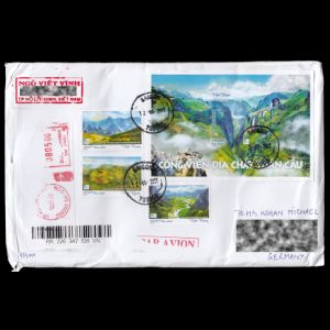
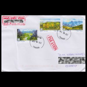
Example of a used cover |
 |
 |
 |
References
Acknowledgements:
Many thanks to
Dr.
Peter Voice from Department of Geological and Environmental Sciences, Western Michigan University,
for reviewing the draft page and his very valuable comments.


