the place where Paleontology and Paleoanthropology meets Philately
Faroe Islands ( Denmark)
Origin of earth on stamps of Faroe Islands
| << previous country | back to index | next country >> |
Contents:
- Country overview
- Philately of Faroe Islands
- Some stamps of Faroe Islands to consider
- References
- Acknowledgements
Faroe Islands is an island country comprising an archipelago of small islands between the Norwegian Sea and the North Atlantic Ocean, approximately halfway between Norway and Iceland, 320 kilometers north-northwest of Scotland.
The area is approximately 1,400 square kilometers with a 2015 population of 48,700. The islands are an autonomous country within the Kingdom of Denmark.
The archipelago is very rugged and has an extremely moderated subpolar oceanic climate that is windy, wet, cloudy and cool year around. In spite of its northerly latitude, temperatures average above freezing year around.
Between 1035 and 1814, the Faroe Islands were part of the Kingdom of Norway.
The 1814 Treaty of Kiel granted Denmark control over the islands, along with two other Norwegian regions: Greenland and Iceland. The Faroe Islands have been a self-governing country within the Danish Realm since 1948. [R1]
The postage stamps and postal history of the Faroe Islands began in the 1860s with a message exchange system called Skjúts, which was before a regular boat service was established between the islands.
Postage is now under the control of Postverk Føroya, the Postage Stamp Department of which has taken over all the work relating to Faroese postage stamps. [R2]
So far there are no single stamp of Faroe islands that directly related to Paleontology.
Some official stamps of Faroe Islands to consider
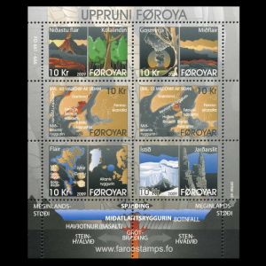
| 25.05.2009 "The origin of the Faroe Islands" [1] | ||
 |
|
|
Notes:
[1] These stamps shows geologic origin of the islands, include the islands position on Pangea continent and its movement to the current position, due to continental drift.
Millions of years ago the continents of the Earth were joined in a super continent called Pangaea.
About 200-135 million years ago, Pangaea split into two parts, Laurasia in the north and Gondwana in the south.
About 60 million years ago the seafloor had started to spread between Canada and Greenland along the Labrador Ridge,
and between Greenland and the Faroe-Rockall plateau along the Mid Atlantic Ridge.
This was the start of an era of intense volcanic activity along the entire continental shelf, and volcanoes appeared
all the way from Greenland, on the Faroe-Rockall Plateau and along the west coast of Scotland down to the south eastern corner of Ireland.
Great parts of the Faroe-Rockall Plateau as well as parts of the British Plateau sank below sea level.
References:
- [R1] Faroe Islands: Wikipedia WikiTravel FlagCounter
- [R2] Postal History and Philately of Faroe Islands:
Wikipedia
Links to official website of the Post Authority, stamp catalog and a list of new stamps of Faroe Islands are here
Acknowledgements:
Many thanks to Dr. Peter Voice from Department of Geological and Environmental Sciences, Western Michigan University, for reviewing the draft page and his very valuable comments.
| << previous country | back to index | next country >> |