the place where Paleontology and Paleoanthropology meets Philately
British Indian Ocean Territory
Charles Darwin on stamps of British Indian Ocean Territory
| << previous country | back to index | next country >> |
Contents:
- Country overview
- Philately of British Indian Ocean Territory
- Official stamps of British Indian Ocean Territory related to Paleontology
- Other stamps of British Indian Ocean Territory to consider
- References
British Indian Ocean Territory (BIOT) is a British Overseas Territory of the United Kingdom situated in the Indian Ocean halfway between Tanzania and Indonesia.
The territory comprises the seven atolls of the Chagos Archipelago with over 1,000 individual islands – many very small – amounting to a total land area of 60 square kilometres.
The largest and most southerly island is Diego Garcia, 27 km2, the site of a Joint Military Facility of the United Kingdom and the United States.
The Chagos islands were first discovered, uninhabited, in the 16th century. The French assumed sovereignty in the late 18th ntury and began to exploit them for copra, originally employing slave labour.
Under the Treaty of Paris in 1814, France ceded to Britain, Mauritius and its dependencies, which included the Seychelles and the Chagos Archipelago.
The Chagos Islands were detached to become part of the British Indian Ocean Territory in 1965.
Since the 1980s, the Government of Mauritius has sought to regain control over the Chagos Archipelago.
On 22 May 2019, the United Nations General Assembly adopted a resolution, affirming that "the Chagos Archipelago forms an integral part of the territory of Mauritius", citing the February 2019 advisory opinion of the International Court of Justice on the separation of the archipelago from Mauritius.
In its advisory opinion, the Court concluded that “the process of decolonization of Mauritius was not lawfully completed when that country acceded to independence” and that “the United Kingdom is under an obligation to bring to an end its administration of the Chagos Archipelago as rapidly as possible”. [R1]
The BIOT Post Office is managed by the Foreign and Commonwealth Office of the British Government and is operated on its behalf by Sure (Diego Garcia) Limited.
The Post Office provides outbound postal services from the island of Diego Garcia. Incoming mail is handled by both the US Postal Service and the British Forces Post Office.
In 2021 the Universal Postal Union (UPU), a UN agency in charge of the world's postal policies, voted to ban the use of British postage stamps on mail to and from British Indian Ocean Territory, instead requiring Mauritian stamps to be used:
"In May 2019, following advice from the International Court of Justice, the UN General Assembly instructed the UN and its specialized agencies to recognize Mauritius’ sovereignty over the Chagos Archipelago and refrain from recognizing or implementing any measure taken by or on behalf of, the British Indian Ocean Territory."
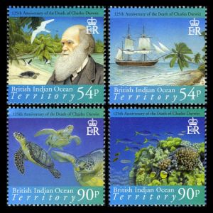
Official stamps of British Indian Ocean Territory (BIOT) related to Paleontology: Charles Darwin
| 23.07.2007 "125th Anniversary of the death of Charles Darwin" | ||
 |
|
|
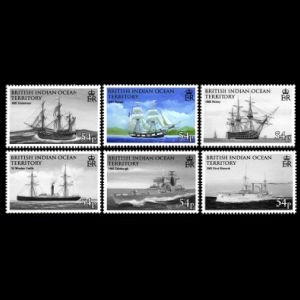
Other stamps of British Indian Ocean Territory (BIOT) to consider: HMS Beagle
| 09.03.2009 "Ships" | ||
 |
|
|
Notes:
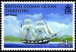
[A1] H.M.S. "Beagle" shown on one of the stamps.

|
| H.M.S. Beagle on stamp British Indian Ocean Territory 2009, MiNr.: 475; Scott: 367. |
HMS Beagle was a Cherokee-class 10-gun brig-sloop of the Royal Navy, one of more than
100 ships of this class.
On the second voyage a young naturalist named
Charles Darwin was on board;
the pivotal role this round the world voyage played in forming his scientific theories made
Beagle one of the most famous ships in history.
Darwin had kept a diary of his experiences, and rewrote this as the book titled Journal and Remarks,
published in 1839 as the third volume of the official account of the expedition.
This travelogue and scientific journal was widely popular, and was reprinted many times with
various titles, becoming known as The Voyage of the Beagle.
This diary is where Darwin drew most of the ideas for his publications.
Darwin attributes his first real training in natural history to his voyage on the Beagle.
[R3]
References:
- [R1] British Indian Ocean Territory: Wikipedia, WikiTravel, FlagCounter.
- [R2] Postal History and Philately of British Indian Ocean Territory:
BIOT Post Office ,
"British stamps banned from Chagos Islands in Indian Ocean" BBC article,
Press release: UPU adopts UN resolution on Chagos Archipelago,
Links to official website of the Post Authority, stamp catalog and a list of new stamps of British Indian Ocean Territory are here. - [R3] HMS Beagle: Wikipedia,
Acknowledgements:
Many thanks to Dr. Peter Voice from Department of Geological and Environmental Sciences, Western Michigan University, for reviewing the draft page and his very valuable comments.
| << previous country | back to index | next country >> |